- +Today's Tides for Swanwick Marina
- +Swanwick Marina's Future Tides
- +Weather for Swanwick Marina
- +Advanced Haven Search
- +Contacts and Emergency for Swanwick Marina
- +Local Navigation Resources
Low Water | High Water |
---|---|
01:00 (0m) | 01:00 (0m) |
13:25 (0m) | 13:25 (0m) |
Now Falling | |
Time to low | 9:02 |
Total fall | 0m |
Remaining fall | |
Tide height over CD |
Mean Spring Curve | Mean Neap Curve | Intervening Period |
Small tidal stream inaccuracies can develop when advancing beyond HW Portsmouth +6. Because of this we only enable today's tidal stream chartlets to advance 24 hours. Future tidal planning is best accomplished by using Swanwick Marina's future tides predictor below.
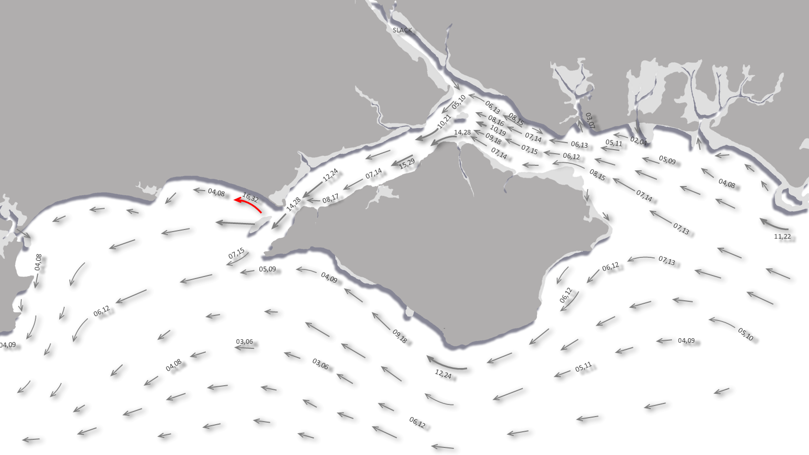
The above image represents the current tidal streams offshore of this haven. Streams attaining three knots and above are highlighted by red arrows . All times are in local time with red text indicating springs, blue indicating neaps and gray between tidal events. Click [+] to advance the estimate by an hour and click [-] to step back. Future tidal planning is best accomplished by using Swanwick Marina's future tides predictor below.
Do you need more information on the tidal graphics?
Arrows represent the direction of tidal streams with lighter or shorter arrows indicating weaker streams. Stronger streams are indicated by heavier or longer arrows, and as mentioned above, red arrows flagging rates of 3 knots and above. Numerals represent [mean neap, mean spring] rates in tenths of a knot. For example the numbers 12,23 would indicate a mean neap of 1.2 knots and a mean spring of 2.3 knots.
More local tidal details
Today's Bursledon tides — High water: , Low water:Today's Dover tides — High waters: 01:06, 13:42, Low waters: 06:44, 19:06
We are now on Springs.
MHWS 4.5m MHWN 3.8m MLWN 1.9m MLWS 0.8m
Standard Port Southampton Mean Tidal Ranges Springs 4.0m; Neaps 1.9m.
During Springs High Water Warsash, at the head of the river, is 10 minutes after HW Southampton and Low Water is the same as LW Southampton. During Neaps High Water Warsash is 20 minutes after High Water Southampton and Low Water is 10 minutes afterwards.
Double High Water occurs at or near Springs and there is a stand, which can last as long as two hours, at other times. Estimates presented are for the first High Water during Springs or the middle of the stand outside of this.
Helmsmen should note the double high tide or stand means the ebb tide has to complete its cycle in 3-4 hours instead of the usual 5 + hours. This means that the rate of the ebb will be significantly greater than the preceding flood tide. This rate could also be increased by land water, after heavy rain, flowing in the river. Be very careful moving into complicated berths on the ebb and it is best to entirely avoid berthing manoeuvres on the first flush of the ebb especially so during Springs.
This tool can be used to estimate future costal tidal streams for this area. All that is required are two simple steps:
Step 1: What is the Dover High Water for the target date?
Use a current Dover Tide Table to find Dover High Water for the target date. The National Oceanography Centre offers online tidal predictions for up to 28 days from today. Click here to open their tide table for Dover
Step 2: Input the target date's Dover High Water
Taking a mean tidal offset from Dover's tide, we expect your targetted date's associated local tide at to be:
High waters: Low waters:
Data based on an average tide is only accurate to within one hour, if you more precise times are required use the ISA tidal predictions, with Bursledon offset -01:00.
Feel free to use our calendar, below, to predict 'Future Tidal Streams' as normal. These are displayed in local time and need no adjustment.
For planning purposes only, not for navigation. Please see our terms and conditions.
Today's overview |
||||
°C °C |
°C °C |
°C °C |
°C °C |
°C °C |
Headline: Heavy showers and thunderstorms this weekend with warm sunny spells.
Today: The cloud will rapidly break up into warm sunny spells during the morning. However some heavy thundery showers will soon follow in the afternoon, particularly in the west. Breezy. Maximum Temperature 24C.
Tonight: Showers tending to fade by Friday evening leaving late sunshine. Low cloud likely spreading across northern and western parts overnight. Thundery showers may arrive over the far southeast after midnight. Minimum Temperature 14C.
Saturday: Early showers pushing northwards. Cloud breaking to sunny spells with heavy, thundery, showers then developing as temperatures rise. Showers most frequent further west. Heavy rain arrives into southern counties overnight. Maximum Temperature 23C.
Outlook for Sunday to Tuesday: Heavy, locally thundery rain, expected to affect much of the region throughout Sunday and Monday. Rain clearing east Monday afternoon, becoming dry overnight. Bright spells and isolated daytime showers Tuesday.
Click [+] to advance by twelve hours and click [-] to step back. The forecasted time is presented in the top left hand corner of the pressure chart. Click the image to display it in a full window.
Get today's Shipping Forecast for this Sea Area
Get today's Met Office Video Forecast
Set your current location | Set the maximum distance you are prepared to travel | Check off what you want |
Coastguard on VHF Channel 16 and this should only be used for distress and urgency calls. Most coastal areas have a good phone signal making it possible to dial 999 or 112 and ask for the coastguard. HM Coastguards Solent area ‘Maritime Rescue Coordination Centre’ MRCC is situated at Lee-on-Solent; MMSI is 002320011. The centre is manned 24x7 and has a rescue helicopter at its disposal. They keep a watch on VHF Ch 16 and also Ch 67 that can be used for routine communications. Solent Coastguard broadcasts a weather forecast on Ch 86 and Ch 23 once an initial announcement has been made on Ch 16.
Whilst operating in the Solent it is advisable to maintain a radio watch on the port working frequency of Channel 12 used by Southampton Vessel Traffic Services (VTS) and shipping. Every 2 hours from 0610-2210 there will be a broadcast on Channel 14, pre-empted by a transmission on Channel 12, giving information on large ship movements, local weather conditions and any new Navigational Warnings.
Other useful contacts
Harbour Master P: +44 1489 576387 VHF Ch. 68 call sign [Hamble Harbour Radio]. The office in Warsash is open 8.30 am to 5 pm daily. If office unavailable Hamble Patrol operates in the summer, 1 April to 30 September, from 6.30 am to 10 pm and in winter, 1 October to 30 April, 8.30am to 5 pm. The patrol is available on M: +44 7718 146380 or +44 7718 146381.
Swanwick Marina, Swanwick, SO31 1ZL
P: +44 1489 884081
E: swanwick@premiermarinas.com
W: https://www.premiermarinas.com/UK-Marina-locations/Swanwick-Marina
VHF: Ch80
Leisure Folios, Admiralty SC5600 ‘The Solent and Approaches’ and the Imray ‘2200 Solent Chart Pack - Selsey Bill to Poole, including the Isle of Wight’. The following Admiralty Charts cover The Solent and Southampton Water. 2045 ‘Outer Approaches to The Solent’, 2035 ‘Western Approaches to the Solent’, 2021 ‘Harbours and Anchorages in the West Solent Area'. Also Imray "C" Chart C3 ‘Isle of Wight’, C15 ‘The Solent’.
Please note eOceanic makes no guarantee of the validity of this information. Whilst every effort has been made to use valid source data and ensure calculations are correct, no warranty is made. All tidal predictions are approximations and differences used to calculate times and heights at secondary ports are based on stated averages that reduce precision. This information is provided as a guide only and is not to be used for navigation. For navigation please refer to published tidal tables. Actual height and time of tides are affected by barometric pressure and other weather effects. Any data provided on this page is entirely used at your own risk and you must read our legal page if you view data on this site.